

01 Feb “The Map That Explained a War: Israel’s Pre-1967 Borders and the Fight for Survival”
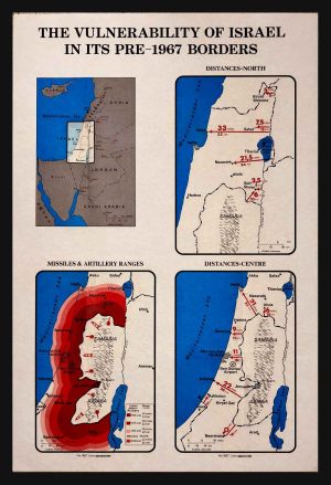
“The Vulnerability of Israel Before 1967 – Rare Official Israeli Explanatory Vintage Map Poster”
The poster “THE VULNERABILITY OF ISRAEL IN ITS PRE-1967 BORDERS” is not a simple map poster or a neutral cartographic object, but a sharp and deliberate explanatory document born out of an existential security reality. In the late 1960s, shortly after the Six-Day War, Israel sought to explain to the world—particularly to an international diplomatic, academic, and public audience—why its pre-1967 borders were indefensible, and why the war was not the result of territorial ambition but of a real and immediate threat to the very existence of the state. The poster does this through clear and uncompromising visual means: alarmingly short distances, bold arrows, weapons-range indicators, and a single dashed line—the Pre-1967 Lines—illustrating just how narrow and fragile the country once was.
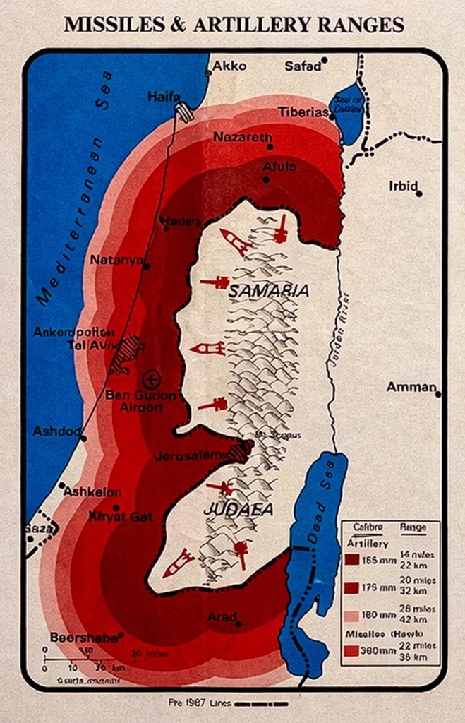
The maps and diagrams present a reality in which Israel’s width in the central region was at times only about 15 kilometers, a distance within which even basic artillery or short-range missiles could paralyze transportation arteries, population centers, airports, and national infrastructure. Tel Aviv, Haifa, Jerusalem, and Ben-Gurion Airport are clearly marked as being within direct firing range. The poster leaves no room for interpretation: before 1967, any full-scale confrontation with neighboring Arab states could have resulted not in territorial loss, but in the destruction of the state itself. This was the core of Israel’s explanatory argument at the time, presented here without rhetoric or exaggeration—only cold geography and numbers.
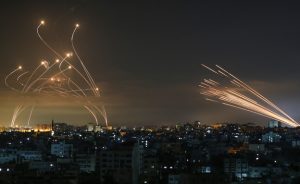
When viewed through the lens of today’s security reality, particularly in the aftermath of the events of October 7, the poster takes on a chilling contemporary relevance. The threat to Israel has not disappeared; it has evolved. Instead of artillery and armored divisions along narrow borders, Israel now faces precision missiles, long-range rockets, drones, and sophisticated fire systems targeting the civilian home front. Iran and its regional proxies pose a broad, multi-front threat, blurring the distinction between front lines and rear areas. In this context, the strategic alliance with the United States and the visible support of the American military in these sensitive times is not merely a political gesture, but a critical pillar of deterrence and defense against a layered existential threat.
The Six-Day War created a new geographic reality, providing Israel with greater strategic depth and more defensible lines. Yet even after the war—as this poster reminds us in retrospect—the debate over borders, security, and legitimacy did not disappear. The poster remains a powerful visual reminder that the discussion surrounding the 1967 borders is not merely theoretical or ideological, but fundamentally a matter of survival, measured in distances, ranges, and a small nation’s capacity to protect its citizens in a hostile environment.


In these days, as the United States stands in a direct and escalating confrontation with Iran and the region is gripped by heightened military tension, the poster gains an additional layer of meaning. Thousands of missiles, rockets, and precision drones held by Iran and its proxies are currently aimed at Israel as a concrete and ongoing threat. Within the American political arena, Israel’s security has once again moved to the forefront, influenced in part by the legacy of Donald Trump and the hardline stance adopted toward Iran during his presidency—withdrawal from the nuclear agreement, severe economic sanctions, and unequivocal declarations of commitment to Israel’s security. The continued and visible support of the United States—through military presence, defensive systems, and intelligence cooperation—reflects a deep understanding of the same strategic vulnerability illustrated in this historical poster: a small state, surrounded by threats, dependent on depth, deterrence, and international backing to ensure its survival.
From a physical and collectible standpoint, the poster is in very good condition, retaining its original fold marks typical of official explanatory posters from this period, with no damage to the graphic content or message. Its impressive large format measures 52 × 92 cm (approximately 20.5 × 36.2 inches). It was printed in English by the Israeli government’s Information Department shortly after the Six-Day War, specifically for an international audience. The poster is composed of four interconnected visual panels: a Middle East map situating Israel within its regional context and emphasizing its geographic isolation; a map of northern Israel highlighting the extremely short distances between borders and key cities and the exposure of the Galilee and Sea of Galilee; a map of central Israel illustrating the strategic bottleneck where the distance from the Mediterranean to the pre-1967 line was minimal, exposing Tel Aviv, Jerusalem, and major airports; and finally, a weapons-range diagram using colored zones to demonstrate how population centers and infrastructure were vulnerable to short-range artillery and missile fire. Together, these four maps form a coherent and powerful explanatory document that merges geography, security, and political narrative—transforming the poster into not only a rare collectible, but a compelling visual testimony to one of the most critical turning points in the history of the State of Israel.
Sorry, the comment form is closed at this time.