

19 Nov Rare JNF ‘Hebrew Land’ Vintage Map Poster – Now Available for Collectors
A 1920s Zionist lithograph from Keren Kayemeth—early use of the term “Hebrew Land.” Limited availability.
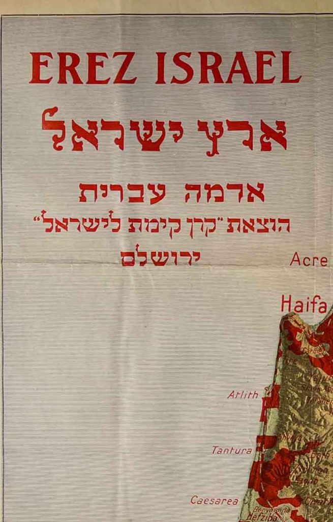
The JNF “Hebrew Land” Map – A Foundational Document in the History of Zionism
For more than a century, maps have been far more than geographic tools. In rare cases—especially in the story of the Jewish people—they become ideological instruments, visual manifestos, and roadmaps for an entire national project.
The “Hebrew Land” map published by the Jewish National Fund (Keren Kayemeth LeIsrael) in the 1920s is exactly such a document: a landmark piece that shaped the emerging national consciousness just as much as it influenced the practical development of Jewish settlement.
This striking lithographic poster, produced in Jerusalem during a decade of intense transformation, reflects the moment when the Zionist movement began shifting from a dream of return to a concrete program: purchasing land, establishing new settlements, and building national institutions.
The map—one of the earliest documented uses of the term “Hebrew Land”—visually expresses the ideological belief that a Jewish national home required tangible grounding in the soil itself.
The Jewish National Fund: The Land-Building Enterprise of the Jewish People
The Jewish National Fund (JNF) was founded in 1901 at the Fifth Zionist Congress, rooted in the realization that the Zionist vision could not be realized without Jewish ownership of land in Palestine.
Over decades, JNF collected donations big and small—from children dropping coins into the famous blue box to generous contributions from affluent communities—and used them to purchase tracts of land that became the base of early settlement.
In the 1920s, following World War I and the establishment of the British Mandate, JNF accelerated land acquisition in key strategic regions:
the Jezreel Valley, the Lower Galilee, the coastal plain, the Jerusalem hills, and more.
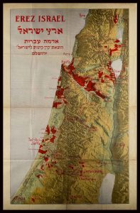
This map captures that dramatic progress: the areas marked in bold red represent JNF lands—plots reserved for the emerging Jewish national presence.
The First Appearance of “Hebrew Land”
One of the map’s most significant elements is the early appearance of the term “Hebrew Land.”
Before the 1920s, Zionism dealt largely with ideas, diplomacy, and ideology. This term reflected a profound shift:
a recognition that the national home required real land, purchased and cultivated by Jews.
“Hebrew Land” was not merely a slogan—it was a practical mission.
The map turned ideology into a visible reality. It was displayed in classrooms, youth movements, community centers, Jewish offices abroad, and Zionist institutions. As an educational and promotional tool, it showed—clearly and powerfully—what the Zionist movement was accomplishing on the ground, not just in speeches.
A Landscape of Early Jewish Settlement: From the Galilee to the South
A close reading of the map reveals a fascinating mosaic of early Jewish presence across the land:
In the Upper and Lower Galilee
Metulla, Rosh Pina, Yesod HaMa’ala, Safed, Tiberias, Degania, Kinneret — names marking the birth of pioneering agricultural settlement and the first kibbutzim.
In the Jezreel Valley
Afula, Nahalal, Ginnegar, Giva, Kfar Yehoshua — communities that grew out of JNF’s extensive reclamation projects that transformed swampy, malarial terrain into fertile farmland.
Along the Coastal Plain
Tel Aviv, Jaffa, Petach Tikva, Rishon LeZion, Rehovot — the seeds of the modern Hebrew city and a rapidly expanding urban landscape.
In and Around Jerusalem
The German Colony, Rehavia, Talpiot, Beit HaKerem — new Jewish neighborhoods reflecting unprecedented development in the capital.
In the South and the Coastal Lowlands
Gdera, Ness Ziona, and the agricultural communities marking the early foothold that would eventually lead deep into the Negev.
Together, these scattered settlements form a rare snapshot of a land awakening—parcel by parcel—through a global Jewish effort.
A Historical Document and a National Legacy
Beyond its value as a rare lithographic poster, the map is a remarkable document for researchers, collectors, and museums.
It records the foundation of one of the most ambitious social and national projects of the modern era: transforming the Zionist dream into geographic and political reality.
Before the State of Israel existed, when the future was uncertain and the obstacles immense, maps like this one hung in classrooms, community halls, and family living rooms. They served as a constant reminder that the dream was not abstract—it was unfolding on the ground, kilometer by kilometer.
A Symbol on the Wall — and the Story of a People
Over the decades, this map has become a symbol:
a symbol of return, pioneering spirit, national reclamation, and the belief that land—real, tangible land—could regenerate a people.
The “Hebrew Land” map is not merely a geographical illustration.
It encapsulates the ethos of early Zionism, the civic courage of a generation, and the conviction that the soil of the homeland could once again nurture Jewish life.
In many ways, it is the blueprint from which the modern State of Israel grew.

Sorry, the comment form is closed at this time.